posts tagged with 'hiking'
camping for climbing
We say we like camping, but we really don't usually do it more than once a year. Which is fine! We have a great time when we do go to the same place every year (and maybe I'll even write about this year's trip someday!). But hearing about all our friends' awesome trips made me want to branch out a little bit, and what better place to branch out to than the only other campground the boys have ever stayed at, so long ago they can't remember. Plus it gave us a chance to climb that mountain we said we were going to climb two years ago.

our goal
That's Monadnock, by the way. It could totally be a day trip from our house—it's just about an hour and a half away—but I wanted to be able to climb it in a leisurely fashion, and I wanted time to relax at a campground too. So two nights of tenting, with the climbing day in between. My original thought was to leave after Backyard Farm Club on Monday afternoon, but when I broached the idea Sunday it was too sudden for Zion. He needs more warning than that, reasonably enough. So we went Wednesday afternoon instead, after Park Day. Which means we got a late start, since Park Day is so hard to leave, and then with the steady drizzle I didn't feel great about trying to start a fire for supper so we stopped on the way for McDonalds (and a salad for Harvey at Hannafords) and got later still. Getting the tents up in the rain and rapidly falling dark was a little stressful, but we made it happen and then enjoyed a delightful evening of reading books and (in my case at least) being glad of not having to cook.
Thursday morning dawned bright and clear, and we took our first real look around the campground. It met our approval. We breakfasted on cereal and milk and bagels, then read some more before getting packed up for the main event of the day. All four backpacks were stuffed with lunches, warm clothes, and most especially water bottles, after our very thirsty experience the last time we climbed a mountain (I really should write about that trip!). At least, most of our packs were stuffed with water bottles; when we got to the trailhead Harvey found that he had left his at the campsite. For a minute he though he'd left his shoes too, so we were all set to go back, but then he found them. And I loaded him up with the almost-full gallon jug of water I had planned to leave in the car for our return, and we headed up.

up...

... and up...
The way up Monadnock is steep and long. And kind of unrelenting, really. Most of the hike is a steady slog up a wide, cobble-y path that feels a lot like a stream-bed. At least there were a few big slabby bits to provide some interest.... plus, as we got higher and higher, glimpses of some amazing views. There was also lots of water, which was delightful on what had turned into a surprisingly hot day.

mountain stream
Towards the top the trees started to thin out, and we really felt how high we were. And the last bit was totally exposed rock, just like a real mountain. There were even a few spots where we needed to use our hands to get up! It felt like a real accomplishment to make it to the top, and it would have been more amazing yet if there hadn't been 30 or 40 people up there already.

almost there!

two ways of feeling at the top
Oh well, at least it wasn't a couple hundred like it would have had it been a weekend. We found a spot a little ways from anybody else (and out of the swarms of bugs that for some reason were plaguing much of the summit) and had our lunches. After lunch I read the boys some of the chapter book we're doing together, and we took pictures of fall foliage and red squirrels.

photo (and nut supply) by Zion
Of course, having gone up we had to go down again. That wasn't easy either. We took a slightly different path, one that was supposed to be a little longer but less steep. It was steep enough, and long enough too. At one point I was sure we had already descended well below our starting point—maybe to the center of the earth. No, it just takes a long time to get down 1,800 vertical feet. Eventually we made it back to the parking lot and the visitor center, where we were delighted with the water fountain and the bottle filler. And with the benches, to be honest; I was entirely ready to sit down.

a pause on the way down
After we had restored ourselves for a little while we wandered over to the gift shop, where the boys took advantage of my pride in their endurance by buying them souvenirs: an otter for Elijah, a coyote for Zion, and a pocket knife and sticker for Harvey. Plus two gatorades. Then we headed back to the campsite. As hot as we were climbing the boys had been very much looking forward to swimming in the pond when we got back down, but it turned out that after over five hours of exertion (and seven hours away from our tents) we were ready for a rest. Good thing we brought lots of books! And good thing that I had planned a simple dinner, because I didn't have much energy for cooking (and all that I did have was taken up by starting a fire with the wet wood we collected). But never fear, there was enough fire for marshmallows to finish the day.

we know how to do things right
the pond the back way
Today was real summer. I was sure this morning that Walden Pond would be closed for lots of the day due to capacity, and I wanted to swim without worrying about that timing. So we went in the back way! Of course, that meant we had to walk a couple miles to get there, but that was all part of the fun.

walk to swim
We parked at the Walden Woods project and walked in along the Sudbury River. We didn't take the longest path, but it was far from the shortest either. The hiking was fun, and it was actually the imminence of lunch time that kept our route from extending even farther. It was lovely and cool in the woods, and the bugs weren't bad at all (we were nervous when right at the start we crossed paths with someone wearing a full mesh veil). We got to the pond right at lunch time, and even though everyone was hungry the water looked so beautiful most of us had to take a dip before eating. And I can tell you that nobody waited half an hour (an hour?!) afterwards!

yay pond
On the way home we took the most direct path to the car—only about a 20-minute walk. It would have been fine even longer though, since spirits were still high. Good outing.
camping 2021 part 2
On our first full day of camping we had big plans! After a breakfast of toasted bagels and cereal, we packed up lunches, swimsuits, warm clothes, and enough snacks to sustain us on an epic hike over a couple of mountaintops. As we picked up our park pass and investigated bus schedules we learned that our hike would have to be even more epic that I had thought, since the closure of the bus stop at Bubble Rock meant we'd have to walk almost a mile and half on the flat around Jordan Pond before we could start climbing. The boys were still game to try, and it was a beautiful start to the expedition, as seen in the first picture of this post. We also got to walk across this super cool bridge:

timber suspension but no railings
Then it was up and up as we ascended the steep east side of Sargent Mountain, the second-highest peak in Acadia National Park (and the highest without a road to the top). I hadn't gone up Sargent since 2012 and the boys (obviously) never have. It's a hike, and we were doing great up the steep part over the first half of the distance up but started to feel a little sloggy as it rounded out at the top and we had to cross over one false summit to see the real top still a quarter-mile away in the distance. But we made it, and only a couple minutes late for lunch! We were hungry enough to put off the celebratory summit photo (made possible by the timer on the camera) until after we ate.

mountaineers
Of course, the real reason to go up Sargent is to visit Sargent Pond, and after a mile or so of descending we were more than ready for a swim. There were enough people there to have some pleasant chats but not so many that it felt crowded, and our time in the water was entirely delightful and free of leeches (leeches had been something of a concern in the planning process).

refreshing waters
(Harvey had actually been there before, but he couldn't remember it.)
From Sargent Pond it's only a third of a mile to the top of Penobscot, so it seemed like a waste not to summit there too. Energy was flagging a bit by the time we reached the top, but you can see that Elijah still had enough juice to throw a pose.

sit down for a minute
We perked up on the long gradual south ridge of Penobscot (over a mile long), but at the end of the ridge the trail turned steeply downward and there were some very nervous moments descending steep cliffy bits on tired legs. I couldn't photograph any of the hardest sections, but this gives some sense of the overall steepness:

good thing we didn't have to come straight down that!
Just before we made it back to the Jordan Pond House and civilization we crossed a stream, where we stopped to soak our sore feet. Everyone was cheering up until, just as we were moving to leave, Lijah slipped and fell entirely into the water. He was very sad. It was a worn-out crew who stumbled onto the concrete paths and mowed lawns at the Jordan Pond House after about six miles of walking and well over 1000 feet of climbing.

made it
The bus trip back to the car was very relaxing, as was an hour or two in or around the pool before we had to head back to the site to start the fire and cook our rice and beans. That day's smores were very well deserved.

yum
adventure time
As well as all the other excitement last week we went on a couple outings close to home and discovered some fun surprises in areas I thought we new pretty well! The first one was last Wednesday, when we brought bikes to Walden Pond so we could ride and get hot before we went in the water. Instead of going on the road (the idea of which made the boys nervous) we took to the paths behind the parking lot, aiming for a spot where OpenStreetMaps suggested that there might—possibly!—be a tunnel under the highway linking up with the Hapgood Wright Town Forest in Concord . After a few wrong turns and some fun short hills, we reached the road... and there it was!
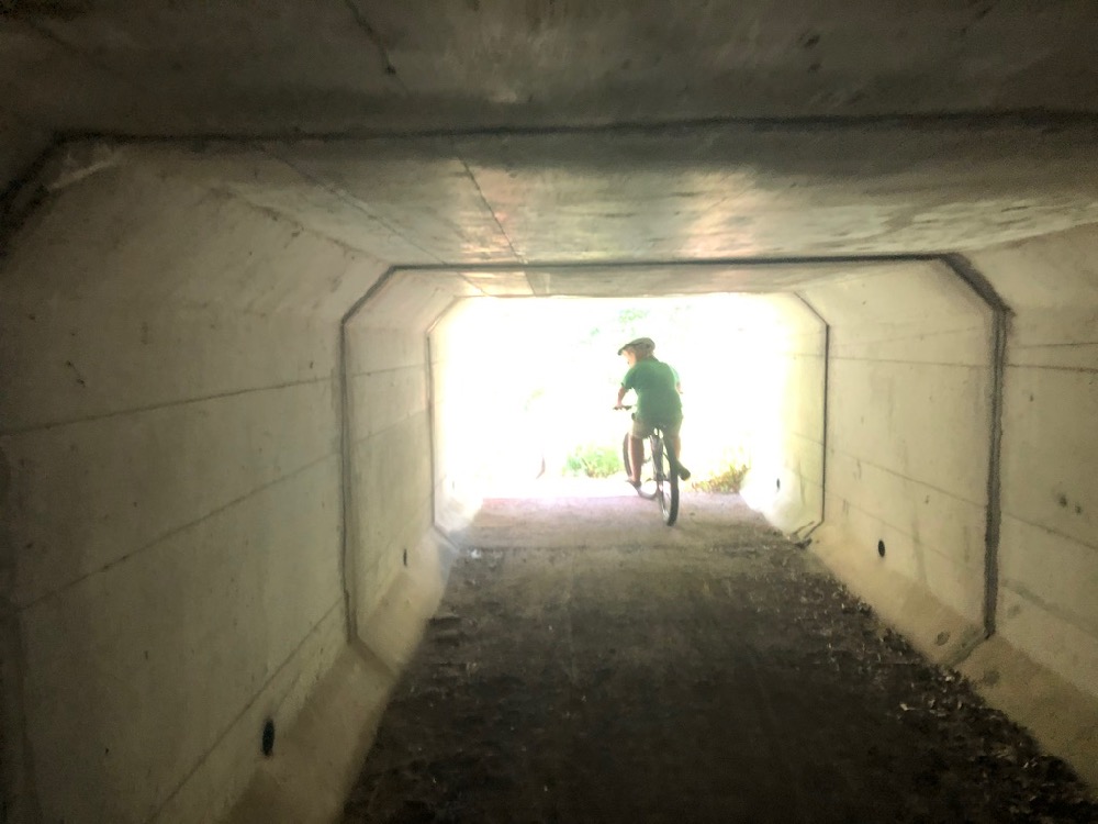
into a mysterious new world
Thrilling as it was, the tunnel wasn't the only exciting part of the outing. We've explored Hapgood Wright lots of times on foot, but bikes always let you see trails differently. This time we noticed lots of amazing downhill runs that we definitely want to go back to do some more! Of course, downhills require uphills, and there were certainly some doozies. Even before we got back to the pond to swim we were glad of a midway rest stop.

cool for feet and water bottles
(If you want to explore the tunnel yourself, just follow our track as shown here.)
Thursday's adventure was a post-strawberry trip to Lowell-Dracut-Tyngsboro State Forest, but that one didn't go as well. Elijah was tired out from the picking, and the other boys have bad memories of riding that woods from when, the last time we tried it, they were feeling a little sick. So their energy wasn't high to start with. The only new discovery we made there was that the paths on the ground are difficult to reconcile with the map—and not knowing where we were or where we were going didn't make Lijah feel any better about the outing! Even though the older two boys had recovered and were having fun, we cut the trip short after just a couple miles.
Then on Friday we were back in Concord for a hike with friends in Estabrook Town Forest. We know it well too, though I will say every time we walk up Punkatasset Hill (88m) I'm surprised at how steep that trail is! Being there with other people let us notice some things more—like stick houses—and some things less, because lots of the time we were deep in conversation. But by far the outstanding discovery of the trip was that they spillway where the pond drains into Sawmill Brook makes a fantastic natural waterslide... but that's a story for another post!
last week's adventures

out and about with friends
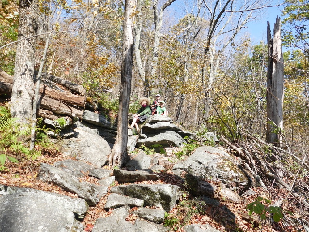
As I mentioned, last week we got to go on a couple hikes with friends. First up was the Fells in Stoneham. I admit that, when I heard the invitation, I wondered why we should be driving 25 minutes—on the highway!—to walk in the woods, when we have plenty of woods around here. But just a couple minutes into the hike I understood. They have rocks! (I guess that's why they call it Stoneham...) We all had a great time mountaineering on the various crags.

a rest on the rocks
It was also lots of fun not to be in charge of operation. Andrew, a veteran of many Fells walks and runs, led us to all the best spots. The coolest was maybe this gorge, which at some point in the early 19th century had been dammed for mills, which as some point in the early 20th century were repurposed into decorative features. It was just like one of those decorative streams in a garden, but 20 times bigger!

water feature
The outing was also made even more exciting by the weather. I'd been out to walk the dogs before we left so I was able to tell the boys to prepare for wintery conditions—and "wintery" wasn't an exaggeration! It wasn't that much above freezing, and with the considerable wind felt well below. Of course the boys complained when they were working hard in sheltered spots and got warm, but we sure wanted those coats and mittens when we got up into the wind! There was even a little snow on the last leg of the expedition.
It was considerably milder, though still breezy, on Friday when we visited Greenough Land in Carlisle with different friends. Unfortunately not quite mild enough to want to go into the water—which otherwise was very inviting!

they wished it was a swimming time!
Our friends had been there before but hadn't explored exhaustively, so they let me push on to the next fun spot and the next until we were all the way around the sizeable pond (not what they had anticipated maybe). But there's so much to see! Besides the amazing old barn—amazing for it's suburban teenage graffiti as well as it's size, complexity, and slate roof—we enjoyed the pond at several spots. The best was the dam outlet where the pond drains down towards the Concord River. We've never been there in the spring before; there was some water running!

I wish I could share the sound too
All in all, it was a lovely two days of expeditions with many miles walked. Good thing we got a weekend to recover!
visit to the potato cave
Often when we're thinking about where to go for a walk Elijah asks if we can visit the potato cave. He's talking about an old root cellar or prehistoric dwelling in the Nashoba Brook Conservation Area in Acton. Friends introduced us to its splendors last spring and we've been back a couple times, but not as much has Lijah would like: because it's almost half an hour away. As nice as it is—and not just for the cave—there are lots of other nice woods in between here and there. But yesterday, when we needed to be out of the house for a while for Leah to do a podcast recording, seemed like a fine time for a return voyage. Plus we'd never been there in the snow!

the main attraction
Now that the weather's turned warmer the snow can be squashy and lots more tiring to walk in, but yesterday afternoon at least the footing was fine and we could go at a good pace. But enough snow was melting that Nashoba Brook—which is really a river, at least compared to the brooks by our house—was roaring cheerfully. After I pulled the boys away from the cave, which doesn't hold as much interest for me or the dogs as it does for them, the water provided some interest as we went along. So, for them, did talking about Minecraft. Sometimes I wonder how much of the outdoors they really experience, when in their minds they're deep in the world of blocky fantasy. But that's fine, they're moving anyways—and let me say, Harvey and Zion are good walkers these days! And with the bright sunshine on the melting snow and the water rushing in the brook, even the most dedicated gamers can pause for a moment to soak it all in.

and enjoy the winter sun
water everywhere
On Christmas day when I took Leah home I also walked the dogs. It wasn't pouring at that point—just steady drizzle—so I wasn't too uncomfortable. And I didn't have any thought that water would be a problem in any other way. In fact, interested in seeing where a foot of snowmelt plus near-constant rain for over 12 hours was going, I headed for the path along Elm Brook. Which was fine—delightful!—until in the last 100 yards we ran into the obstacle seen in the last image of this post. Refusing to walk all the way back the way I'd come, I found a fallen log across a drainage ditch a little ways back that bore my weight, barely, to let me escape from the trap I'd walked into (Blue jumped the ditch cleanly; Scout had a misstep and fell in, but it didn't matter too much because he was already soaking). It was the most water in Elm Brook in years! And it wasn't the only place where we found high water this week.

good thing it no longer houses any boats
On Sunday, I took the dogs for a long walk around Fairhaven Hill. I went the opposite way than we usually go and I came down towards the river on the second half of the walk, and when I reached the boathouse—looking forward to seeing it with enough water to be usable, at last—I found that the river's rise had overshot and the whole dock was underwater. Oh well. The low path by the river was also impassible, and further along the woods looked entirely different with the water coming up dozens of yards higher and bringing the river to places that, just a couple weeks ago, felt entirely removed from it. Then in today's walk the October Farm Riverfront was even more dramatically different: a big chunk of the main path along the river was entirely under water. So was even more of the opposite shore, to the point that the boys were having trouble believing that it could ever have been as close as those trees coming up out of what looked like an endless sheet of water. If we were getting bored of visiting the same places over and over again, all this water certainly makes them interesting again!
the bones of the the earth
We took a walk this afternoon at Whipple Hill in Lexington. It was the first time we'd been there in a couple months, and it sure looks different in November than it did in early September! With the leaves down, the steep hilly terrain is exposed, as are all kinds of delightful rock outcropping that tempted us to explore them. (We saw a good-sized group of kids with a pair of adults on the best of them; I wonder if they were another homeschool group?) And from the top of the hill, which is the highest point in Lexington, we could see for miles and miles—much better than in summertime when it's enclosed with leaves. I think we could see Mt Wachusset looming in the distance, but of course we couldn't be sure. It was something impressive anyways! We also spotted lots of fun looking lines for biking. We may be making a return trip there soon!
our first mountain
We've done lots of hiking this year—or walking in the woods, at least—but we haven't gone up any mountains. We usually save mountain climbing for our annual Maine vacation, but of course that didn't happen this summer. And anyways those are kind of mini-mountains: some fun and challenging climbs and impressive views, but not too much actual altitude (of course, when you're starting from sea level it all counts, but still). So when I heard from a neighbor that his fourth- and first-graders were climbing local mountains this fall I thought right away that it was something we might try too. Last week we started with the littlest closest one, Mount Wachusett.
mountaineers
Not having done anything like this before, I spent hours pouring over maps and guidebooks—or the online version, at least. I love OpenStreetMaps, but it doesn't have any context for the trails it shows, and it's terrible at locating parking. So I also used the official Massachusetts State Parks page, plus some guidance from other websites with details about particular trails. Nobody writes that kind of thing about places like the October Farm Riverfront (they should! I should!) but it turns out that lots of people like talking about climbing mountains. It made me much more confident in setting out last Thursday morning bright and early for the hour-long trip to the base of the mighty peak.
We got a new audiobook for the drive—The House of Many Ways, by Diana Wynne Jones—so the trip went quickly. When we reached it we marveled at the ski slopes as we drove by, then stopped briefly at the visitor center to pick up a trail map in case I didn't have cell service for at any point on the trip. It would have been less brief but the visitor center was closed—even the portapotties!—so we piled back in the car for the two minute drive to the parking lot at the trailhead where we wanted to go up.
My thought was to go up the steepest trail on the mountain, because Lijah likes mountain climbing quite a bit more than hiking, at least when he's primed with the expectation of being on an actual mountain. But I wanted to do a loop down (especially since that steepest way is only half a mile to the top!), and I didn't want to get up to the top right away and then have a long walk to finish off. So even through there's a lot at the bottom of the steep trail, we parked about a mile away and started off with a walk on a trail parallel to the road. Judging by the map I had thought it would be pretty flat, but it actually went up a fair grade, in addition to being made of boulders for much of the route. It felt delightfully mountainy! After that, though, the turn onto the steep path up was something of a disappointment when we saw that it was all stairs. At least for the second half the woods thinned out a bit and we could chose to walk on the bare rocks beside the stairs—which of course we did.
There was some disappointment at the summit too: even though I'd told them what to expect, the boys were a little dismayed to see the parking lot and the observation tower and all the people—yes, even on a weekday morning the top of Wachusett was a little crowded. But when we started to pay attention to the views I finally got the kids to understand that they were actually up higher than they had ever been before in their lives. That was cool in its own right, and it also meant that we could see pretty far (even though it was frustratingly hazy for October). There were four signs around the observation deck with labeled pictures of the landmarks you could see in each direction; spotting the tall buildings way off in Boston was pretty cool, but the massing mountains of Vermont were the most exciting. We could see Vermont! A magical place that they'd barely ever thought about before! Then we found a quiet spot to have lunch. Quiet in that is was out of the way of people, that is; the wind was plenty loud! Oh yeah, I forgot to say that whatever other ways it was lacking as a mountaintop Wachusett certainly provided an appropriate amount of summit wind.

the path down
The way down was longer than the way up, and more interesting. If I were to do the mountain again—which frankly I can't imagine doing, unless friends want to go with us—I'd definitely go up that way and down yet another way. We passed through different types of woods and one small meadow orchard, and took a little detour to visit the grandly named Echo Lake (pretty, but smaller than most ponds we know). Then it was an easy walk back to the car. The whole thing was far from the longest hike we've ever done, even outside of camping, and when after looking at the clearing haze I jokingly suggested going back up to take another look at the distant hills Harvey was ready to go for it. Really, we all could have made it back to the summit pretty easily a second time. But we did have obligations for later in the afternoon, and the audiobook was calling, so we were all happy enough to head for home... thinking about the next mountain we might climb. "How much higher is Mount Washington?" Harvey wanted to know.

looking away to Mt Monadnock... a more realistic next goal!
multimodal exploration of Fairhaven Bay
A week or two ago we set out to explore a new bit of land, spanning Concord and Sudbury between Walden Pond and the river. We started out by visiting Mount Misery, as described here; that was fun, but we didn't actually make it into Adams Woods or Wright Woods, where I had actually thought of visiting. So I searched for an alternative entrance to the Wright Woods and found a closer way in, off of Sudbury Rd in Concord. Our first trip there turned into an epic two-hour walk around Fairhaven Hill, with many delightful sights along the way.

Blue looks at the Bay
One highlight was Fairhaven Bay, and the old boathouse looking out over this unexpected stretch of open water in the middle of the Sudbury River. The path went by an old boathouse, which was a lovely place to stop for a snack; we only we could have found some way to get into it! We also enjoyed climbing on an old ruined chimney (pictured here) and scrambling on some rocky cliffs above the river.

cliffs are hard to photograph
Writing on the internet suggested there were some cliffy trails to explore, but even though we walked for a while we didn't find them. A long while, actually: doing a loop all around Fairhaven Hill was maybe a bit much. We've been doing lots of hiking lately, though, so we all survived.

kind brother
A couple days later we revisited the woods, this time by water. We put the canoe in at a launch near Mount Misery (which required paddling through a very shallow, algae-infested channel) and headed downstream into Fairhaven Bay. On the way we passed by the beach where Zion swam on our first visit; it was even more fun reaching it by boat. Even though the weather was sunnier we were all happy enough to be on the water that nobody felt like it was necessary to go in it.

beached
There was enough breeze to make paddling across the middle of Fairhaven Bay exciting; you don't expect waves like that on a river trip! It was a beautiful sparkling day though, and it felt absolutely delightful to be out on the water. We saw just one other group paddling, in a pair of canoes, and we greeted each other enthusiastically—just knowing we were both doing the loveliest possible thing at that particular moment.

just the best
At the other side of the bay we reached the boathouse. I only wish there was a little more water, though, since right now the river is too low to get into it. The little streams coming out of the Adams woods were also impassible due to low water, but around them we saw lots of interesting birds.

there were also geese and swans
But while the boating was fun, it didn't get us any nearer to finding the big cliffs. And nobody wanted to walk all that way again. So this past Sunday we went back with bikes. And it turns out that the Wright Woods is great for cycling, with trails that are smooth enough for even Lijah's 16-inch wheels (though his fearlessness in attacking obstacles did lead to some nervous moments for me!) and plenty of fun downhill segments. And the cliffs! Approaching them we were forced off the bikes in short order.

push!
That may not look all that steep in the picture, but I assure you that even at that point it was just about unrideable. And it got crazier! The scramble up the last bit was a challenge even on foot!

we can do it!
Disappointingly, the top was a rich person's yard. They did have a very cool boat-shaped observation platform and a nice firepit, but it wasn't really a place for us to linger (though of course we did pause for water and snacks just below the top). Still, we felt like we had conquered a real climb!

the view from the top
After all those trips, we now feel like those woods have been pretty comprehensively explored. But that doesn't mean that we're done there: now that we know the place, we're ready to go back and have some fun!